- Daily & Weekly newsletters
- Buy & download The Bulletin
- Comment on our articles
Related articles
Recent


Popular


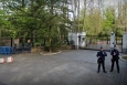
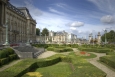
Laeken Palace plainly visible in Google Maps

Google Maps' satellite images reveal all the secrets of the Belgian Royal Palace in Laeken, while, for security reasons, surveillance of the royal domain is strictly prohibited since 1954. Nonetheless, Google Maps provides stunning satellite photos of the royal domain, including the castle and its magnificent complex of greenhouses, parks and ponds. Upon zooming in, the software goes into a 3D configuration, allowing for an even more detailed view of the grounds. The ban on surveillance of royal estates in Belgium, and in particular the Royal Palace of Laeken, is still valid and published in a Royal Decree dated June 11, 1954. Article I of the decree prohibits aerial photos of the territory within a 1,500-meter radius of the Royal Castle of Laeken.


